Campbell Island
Explore Campbell Island
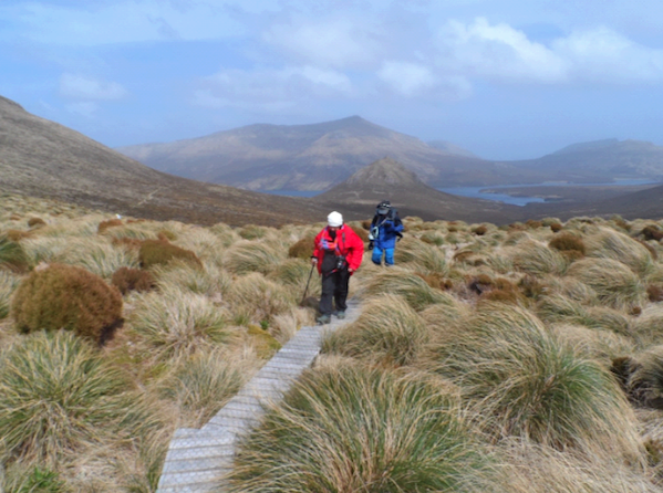
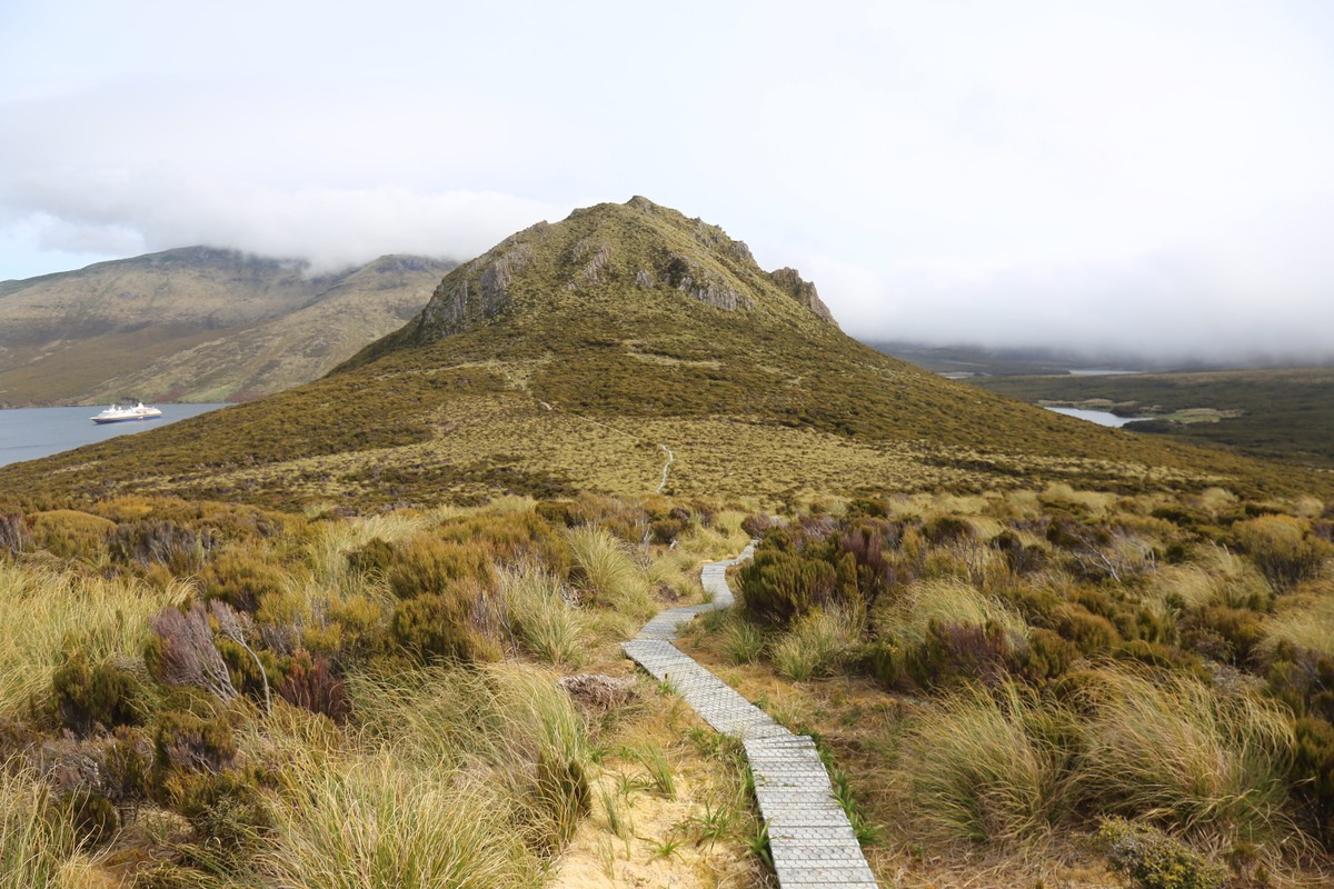
The Campbell Islands, the most southerly of the New Zealand Subantarctic Islands, lie on the Campbell Plateau – a submerged portion of the New Zealand continental landmass. This is located 700 kilometres (435 miles) south of New Zealand’s South Island and 270 kilometres (170 miles) south-east of Auckland Island. The 115 square kilometre (44 square miles) island is shaped somewhat like a giant bird, measuring 16 kilometres (10 miles) east to west and 15 kilometres (9 miles) north to south. It is the highly eroded remnants of an ancient volcano last active several million years ago. The largest of the offshore islands include Dent Island, Jacquemart Island, and Île de Jeanette Marie. Other significant islands include Survey Island, Monowai Island, Wasp Island and the Hook Keys.
Rat Eradication Project
In June 2001 the New Zealand Department of Conservation embarked on the world’s most ambitious rodent eradication project. The plan was to completely eradicate 11,300 hectares (27,900 acres) of Campbell Island of the Norwegian Rat which had been accidentally introduced shortly after the island’s discovery in 1810. The rats had decimated the island’s wildlife, driving three land birds to extinction and ridding the main island of several more seabirds. The project involved 19 persons, two ships, five helicopters and 120 tonnes of cereal pellets laced with rat poison. It was completed at a total cost of $2.6 million. Now it has been deemed successful and visitors on ship tours of the Southern Pacific are heartened to see resurgent vegetation and wildlife.
Legend of the ‘French Princess’
This legend of the exiled princess, of which there are several versions, all highly romantic, is associated with heather plants that grow on the island, in all probability introduced by an early whaler or sealer. According to the legend, a stone fireplace, a shell-paved pathway to the nearby water’s edge, a ragged stand of flax bushes – at one time evidently a neatly planted windbreak – and some straggling heather plants identify the remains of the lonely home of an exiled lady of noble birth who is described usually as ‘the French princess’ or ‘the Jacobite princess’. About 10 years after the Napoleonic Wars had ended, this ‘princess’ is said to have been involved in a plot which threatened to overthrow the then French monarchy. One version says that she was a daughter of Bonnie Prince Charlie, but this account is perhaps the least credible, because that daughter died in France. Another version states that the exiled princess was betrothed to a Scottish nobleman who laid claim to the thrones of England, Scotland and France. For some reason it was desirable to send her out of harm’s way. She was therefore sent to the antipodes in the care of a sea captain who eventually put her ashore at Campbell Island. A small sod hut was built for her at Camp Cove and there, it is said, she was found dead of starvation a year later. A patch of Scottish heather was found near the hut which according to the legend was planted by the princess to remind her of her lover.
Explore Campbell Island
The Campbell Islands, the most southerly of the New Zealand Subantarctic Islands, lie on the Campbell Plateau – a submerged portion of the New Zealand continental landmass. This is located 700 kilometres (435 miles) south of New Zealand’s South Island and 270 kilometres (170 miles) south-east of Auckland Island. The 115 square kilometre (44 square miles) island is shaped somewhat like a giant bird, measuring 16 kilometres (10 miles) east to west and 15 kilometres (9 miles) north to south. It is the highly eroded remnants of an ancient volcano last active several million years ago. The largest of the offshore islands include Dent Island, Jacquemart Island, and Île de Jeanette Marie. Other significant islands include Survey Island, Monowai Island, Wasp Island and the Hook Keys.
Rat Eradication Project
In June 2001 the New Zealand Department of Conservation embarked on the world’s most ambitious rodent eradication project. The plan was to completely eradicate 11,300 hectares (27,900 acres) of Campbell Island of the Norwegian Rat which had been accidentally introduced shortly after the island’s discovery in 1810. The rats had decimated the island’s wildlife, driving three land birds to extinction and ridding the main island of several more seabirds. The project involved 19 persons, two ships, five helicopters and 120 tonnes of cereal pellets laced with rat poison. It was completed at a total cost of $2.6 million. Now it has been deemed successful and visitors on ship tours of the Southern Pacific are heartened to see resurgent vegetation and wildlife.
Legend of the ‘French Princess’
This legend of the exiled princess, of which there are several versions, all highly romantic, is associated with heather plants that grow on the island, in all probability introduced by an early whaler or sealer. According to the legend, a stone fireplace, a shell-paved pathway to the nearby water’s edge, a ragged stand of flax bushes – at one time evidently a neatly planted windbreak – and some straggling heather plants identify the remains of the lonely home of an exiled lady of noble birth who is described usually as ‘the French princess’ or ‘the Jacobite princess’. About 10 years after the Napoleonic Wars had ended, this ‘princess’ is said to have been involved in a plot which threatened to overthrow the then French monarchy. One version says that she was a daughter of Bonnie Prince Charlie, but this account is perhaps the least credible, because that daughter died in France. Another version states that the exiled princess was betrothed to a Scottish nobleman who laid claim to the thrones of England, Scotland and France. For some reason it was desirable to send her out of harm’s way. She was therefore sent to the antipodes in the care of a sea captain who eventually put her ashore at Campbell Island. A small sod hut was built for her at Camp Cove and there, it is said, she was found dead of starvation a year later. A patch of Scottish heather was found near the hut which according to the legend was planted by the princess to remind her of her lover.

Geography
Geographical Information: 52º 33’S, 169º 09’E, in the South Pacific Ocean, 700 kilometres south of New Zealand
Area: 11,331 hectares
Maximum Altitude: 567 metres, Mt Honey
Campbell Island is thought to have been formed, for the most part, by a shield volcano whose periodic eruptions covered about two-thirds of the surface. On the west coast, there are thick layers of ash with pyroclastic inclusions. Numerous basaltic dykes intrude into sedimentary rock. The west coast has high cliffs with numerous caves and arches formed by marine erosion, while the effects of glaciation can be seen on the east side of the island.
High and rugged in the south (up to 570 metres or 1,867 feet), Campbell Island slopes off more gently to the north where smoothed ridges and open valleys suggest considerable recent glaciation. The east coast is broken by the two long, narrow, sheltered inlets of Perseverance and North East Harbours; the former, almost severs the island in two. Off the cliffed coasts of the west and south are several little rocky islets. The geological structure of the island is rather complex. There are some scattered sedimentary beds, but most of the surface rocks are nearly horizontal sheets of lava and scoria, with older coarse-grained gabbros in the rugged south-west.
The basement rocks are composed partly of schist, probably of lower Palaeozoic age (dating from 640 million years ago). This crops out at the base of the cliff west of Northwest Bay and on the lower foreshore at the head of Perseverance Harbour. Unconformably overlying the schist is a Cretaceous sequence of sandstone, conglomerate and carbonaceous mudstone. These are followed in turn by Tertiary period Tucker Cove Limestone, about 170 metres (560 feet) thick and exposed near sea level where it has been domed upward by movement at the central part of the volcano. The Shoal Point Formation is a marine fossiliferous deposit of re-worked volcanic sediment. It is comprised of yellow-green tufts and dark coarse-grained breccia overlies the Tucker Cove Limestone to crop out extensively in western and central areas. Grey gabbro and Menhir gabbro of the Miocene age extends north to Northwest Bay.
Nearly two-thirds of the island is covered by volcanic flows which always overlie the Shoal Point Formation. The flows erupted from the centre, north of Northwest Bay, now removed by marine erosion. Individual flows usually dip at 1 to 4 degrees, and vary from 1 to 50 millimeters (1/64th to 2 inches) in thickness. Together they have a total thickness probably in excess of 300 metre (985 feet). Beeman Hill appears to constitute the neck of a subsidiary cone.
The island was subjected to the action of ice during the Pleistocene era 2 million years ago, but there are differing opinions as to the origins of the glacial landforms. On the evidence of the glacial troughs and cirques, Fleming (1977) suggests that permanent snow and ice accumulated to about 160 metres (525 feet). Beggs (1980) notes that the topography is not as steep as in classical glacial terrain and that there is no obvious source area for large valley glaciers. He suggests that periglacial processes may have been the principal agents of land sculpting. Moraine, fluvoglacial sediment, and raised beach deposits are found covering limited areas of the island.
There is a pronounced topographic influence on soil development. Deep peat occupies flat and gently sloping areas, but on steeper surfaces the mineral content of the soil increases and the peat mantle is generally less than 2 metres (6½ feet) thick. The mass movement of peat, especially over impervious bedding planes in the sedimentary rocks, is widespread and conspicuous. Other forms of erosion include deep-seated slumps, and in isolated areas, tunnel gully erosion and scree erosion. Wind erosion, however, is the most extensive form as revealed by blowout scars, especially on exposed ridges and spurs at higher altitudes. The soft, weakly consolidated peat is easily destroyed and this exposes the drier surface layer of soil to erosion by wind and water.
READ LESS
History
Campbell Island was discovered in January 1810 by Captain Frederick Hasselburg of the sealing brig Perseverance. Hasselburg named the island after his employers Robert Campbell and Co. of Sydney. On a later visit that year Captain Hasselburg, along with a woman called Elizabeth Farr and a young boy called George Allwright, were drowned when their jollyboat capsized in Perseverance Harbour. A man named Jas Bloodworth pulled the body of Elizabeth Farr ashore, and she was probably buried in a cove at the head of the harbour.
When a new sealing ground was discovered, the find was usually kept secret, for once its whereabouts became known the unregulated slaughter that followed quickly reduced seal numbers to an unprofitable level. Little is therefore known of sealing visits to Campbell Island. Around this time, sealing activity was declining in the Subantarctic region, but the taking of skins continued sporadically until about 1830. The New Zealand Government’s efforts to conserve seals by patrolling during the closed season failed because of the remoteness of the islands and the resourcefulness of the poachers.
After the initial sealing period there followed a period of exploration into the region south of the 60th parallel. In 1838 Balleny and Freeman, in the Eliza Scott and the Sabrina respectively, set out to explore the eastern sector of this region. They used the Subantarctic Islands as stepping stones, taking sealskins and oil to offset expenses, and water and wood to prolong the voyage. They visited Campbell Island from January 10 to 17, 1839. On the first day, Freeman found four people who had been left on the island four years earlier by a sealing ship. The extent to which the seal population had diminished was witnessed by the fact that this party had collected only 170 skins.
In the 19th Century some exploratory expeditions were sponsored by governments, often as a result of the petitions of scientific and learned societies. The members of two such expeditions spent some time on Campbell Island. The first of these was the British James Clark Ross expedition of 1840 to 1842. The expedition’s objective was to identify whether or not the islands were once part of a main continent, or whether they had been created by isolated uplift and volcanic events. Two of the scientists accompanying Ross, Hooker and Lyall, compiled the first plant and animal inventories for Campbell Island.
The second expedition was sponsored by the Government of France, with the goal of observing the trajectory of Venus. In 1873, a preparatory expedition under Captain J. Jacquemart on board the frigate Vire spent almost a month at the island. The ship returned with the main expedition party, led by A. Bouquet de la Gyre, in 1874 and remained for three months. Although Venus was only glimpsed momentarily as it began to cross the sun, the other scientific findings of the party made the expedition a success. One member of this expedition, M. Duris, died of typhoid fever on the island and was buried on the point opposite Venus Cove.
From 1868 to 1923, both British Navy and New Zealand Government vessels made periodic visits to Campbell Island to service a castaway depot at Depot Point, Perseverance Harbour, one of several erected on the Subantarctic Islands.
Sheep, goats and pigs had been liberated at various times prior to 1895 with the intention of providing sustenance to the shipwrecked, but none of these animals survived for very long. Fires had been started occasionally by accident or by design and rats had been reported as well established on the main island by 1874. However, it was after 1895 that large-scale modification of the island’s vegetation was precipitated by the establishment of a farm when it was leased to J. Gordon for a term of 21 years. Sheep were re-introduced at that time. Twelve years later, in 1907, 10 scientists from the Philosophical Institute of Canterbury’s Subantarctic Islands Expedition spent 8 days on the island. They were the first scientific group to record the effect of sheep grazing on the vegetation.
Since the islands’ discovery in 1810, whalers were well aware of the Campbell Islands’ close proximity to routes used by whales making their annual winter migration to the north. The last of the shore whaling stations was located at Northwest Bay and operated from 1909 to 1916 in conjunction with the management of the sheep run. The whalers’ tow boat was lost in 1913, after which few whales were caught.
The farming era lasted until 1931. The original and renewed leases had changed hands a number of times and an unreliable transport system, accidents and a worldwide recession finally made farming economically unviable. The farmers withdrew and left about 4,000 sheep and between 20 to 30 cattle unattended on the island. In 1937 the second lease expired and was not renewed.
During World War II a coastguard station was operated at Tucker Cove on the north shore of Perseverance Harbour. After the war, the facilities were used as a meteorological station until 1958, when a new one was established at Beeman Cove, just a few hundred metres further east. This station was manned permanently until 1995 when a fully automatic station was established. Today, human presence is limited to periodic visits by research and conservation expeditions.

Campbell Island Cliffs
Campbell Island was discovered in January 1810 by Captain Frederick Hasselburg of the sealing brig Perseverance. Hasselburg named the island after his employers Robert Campbell and Co. of Sydney. On a later visit that year Captain Hasselburg, along with a woman called Elizabeth Farr and a young boy called George Allwright, were drowned when their jollyboat capsized in Perseverance Harbour. A man named Jas Bloodworth pulled the body of Elizabeth Farr ashore, and she was probably buried in a cove at the head of the harbour.
When a new sealing ground was discovered, the find was usually kept secret, for once its whereabouts became known the unregulated slaughter that followed quickly reduced seal numbers to an unprofitable level. Little is therefore known of sealing visits to Campbell Island. Around this time, sealing activity was declining in the Subantarctic region, but the taking of skins continued sporadically until about 1830. The New Zealand Government’s efforts to conserve seals by patrolling during the closed season failed because of the remoteness of the islands and the resourcefulness of the poachers.
After the initial sealing period there followed a period of exploration into the region south of the 60th parallel. In 1838 Balleny and Freeman, in the Eliza Scott and the Sabrina respectively, set out to explore the eastern sector of this region. They used the Subantarctic Islands as stepping stones, taking sealskins and oil to offset expenses, and water and wood to prolong the voyage. They visited Campbell Island from January 10 to 17, 1839. On the first day, Freeman found four people who had been left on the island four years earlier by a sealing ship. The extent to which the seal population had diminished was witnessed by the fact that this party had collected only 170 skins.
In the 19th Century some exploratory expeditions were sponsored by governments, often as a result of the petitions of scientific and learned societies. The members of two such expeditions spent some time on Campbell Island. The first of these was the British James Clark Ross expedition of 1840 to 1842. The expedition’s objective was to identify whether or not the islands were once part of a main continent, or whether they had been created by isolated uplift and volcanic events. Two of the scientists accompanying Ross, Hooker and Lyall, compiled the first plant and animal inventories for Campbell Island.
The second expedition was sponsored by the Government of France, with the goal of observing the trajectory of Venus. In 1873, a preparatory expedition under Captain J. Jacquemart on board the frigate Vire spent almost a month at the island. The ship returned with the main expedition party, led by A. Bouquet de la Gyre, in 1874 and remained for three months. Although Venus was only glimpsed momentarily as it began to cross the sun, the other scientific findings of the party made the expedition a success. One member of this expedition, M. Duris, died of typhoid fever on the island and was buried on the point opposite Venus Cove.
From 1868 to 1923, both British Navy and New Zealand Government vessels made periodic visits to Campbell Island to service a castaway depot at Depot Point, Perseverance Harbour, one of several erected on the Subantarctic Islands.
Sheep, goats and pigs had been liberated at various times prior to 1895 with the intention of providing sustenance to the shipwrecked, but none of these animals survived for very long. Fires had been started occasionally by accident or by design and rats had been reported as well established on the main island by 1874. However, it was after 1895 that large-scale modification of the island’s vegetation was precipitated by the establishment of a farm when it was leased to J. Gordon for a term of 21 years. Sheep were re-introduced at that time. Twelve years later, in 1907, 10 scientists from the Philosophical Institute of Canterbury’s Subantarctic Islands Expedition spent 8 days on the island. They were the first scientific group to record the effect of sheep grazing on the vegetation.
Since the islands’ discovery in 1810, whalers were well aware of the Campbell Islands’ close proximity to routes used by whales making their annual winter migration to the north. The last of the shore whaling stations was located at Northwest Bay and operated from 1909 to 1916 in conjunction with the management of the sheep run. The whalers’ tow boat was lost in 1913, after which few whales were caught.
The farming era lasted until 1931. The original and renewed leases had changed hands a number of times and an unreliable transport system, accidents and a worldwide recession finally made farming economically unviable. The farmers withdrew and left about 4,000 sheep and between 20 to 30 cattle unattended on the island. In 1937 the second lease expired and was not renewed.
During World War II a coastguard station was operated at Tucker Cove on the north shore of Perseverance Harbour. After the war, the facilities were used as a meteorological station until 1958, when a new one was established at Beeman Cove, just a few hundred metres further east. This station was manned permanently until 1995 when a fully automatic station was established. Today, human presence is limited to periodic visits by research and conservation expeditions.
Campbell Island Cliffs
READ LESS
Flora & Fauna
Flora
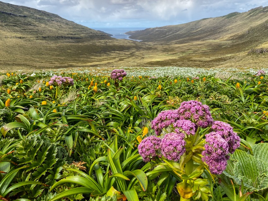
The vegetation of the Campbell Islands is predominantly tussock grassland, shrub land and herb field. Dracophyllum species, Coprosma species and Myrsine approach tree size – 5 metres or 16½ feet – in sheltered places. Limited tree growth results from high winds combined with cool temperatures. One introduced specimen of Picea (spruce) grows on the island and reaches about 6 metres or 19½ feet in height.
For ecological description, Meurk (1977) divides the vegetation into three super-oceanic altitudinal zones: the upper alpine, lower alpine and subalpine. Within these zones he also recognises several intra-zonal communities and some induced states. The most extensive associations are described below.
Sub-Alpine Zone
This zone is characterised by a dwarf forest of Dracophyllum scoparium and Dracophyllum longifolium, with Coprosma species and Myrsine, which in places attains a height of 5 metre (16½ feet).
Tall ferns, Polystichum vestitum and Histiopteris incisa, provide a lower middle stratum – about 1 metre (3.3 feet) high – in glades and bush margins. The ground layer comprises herbs such as Epilobium pedunculare, Stellaria decipiens and Uncinia species, as well as the mosses Ptychomnion densifolium and Acrocladium auriculatum. Epiphytic lichens Pseudocyphellaria species, Sphaerophorus species and Psoroma species), mosses (e.g. Macromitrium longirostre), liverworts and the ferns Grammitis magellanica and Hymenophyllum minimum are also present. The abundance of Myrsine and Coprosma seedlings along with the lack of Dracophyllum juveniles suggest that a true steady state has not yet been reached.
Other associations recognised within this zone are:
i) Poa tall tussock grassland. This is found on steep, windy slopes along the west coast and harbour shorelines. It can consist of nearly pure Poa litorosa, but Bulbinella rossii, Polystichum vestitum, Epilobium pedunculare, Stellaria decipiens, Acaena minor antarctica and Cardamine corymbosa are among the many sporadic associates.
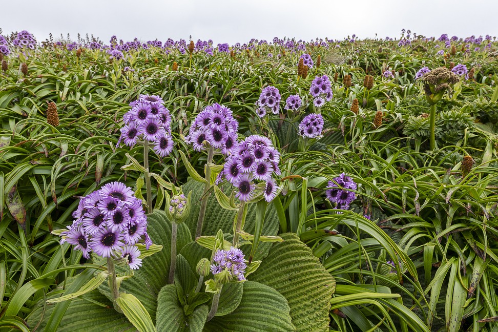
ii) Tall tussock/megaherb field. Because of the highly palatable nature of the dominant plants i.e. Poa foliosa, Stilbocarpa polaris and Anisotome latifolia, 85 years of sheep grazing has greatly restricted the distribution of this association. With the removal of the sheep and the rats the megaherb fields are spreading and regaining dominance.
iii) Littoral/rock association. This tightly integrated association with a clear internal zonation is found either within the splash zone or on coastal cliff crests. Littoral lichens and the moss Muelleriella crassifolia, vascular plants such as Tillaea moschata, Scirpus cernuus and Colobanthus muscoides are found above brown and red seaweeds and blue-green algae. Inland of this band, Poa foliosa can be found.
iv) Salt marsh vegetation of Puccinellia chathamica, Cotula plumosa and Tillaea moschata is found on the upper reaches of tidal flats in the harbours.
Lower Alpine Zone
Chionochloa tall tussock grassland is now largely confined to the eastern extremities of the island, North East Harbour Valley, Beeman Hill, the island off Ramp Point at the eastern end of Penguin Bay, and some coastal cliffs. In its most developed phase Chionochloa antarctica is accompanied only by other tall species such as Polystichum vestitum (a fern), Pleurophyllum speciosum, and scattered shrubs. Smaller herbs are sparse and show the effects of lack of light. Dracophyllum scoparium and D.longifolium may dominate up to about 180 metres (590 feet) above sea level in sheltered areas. This association has greatly increased its range since the 1940s by invading tussock meadows made vulnerable through the burning and grazing of Chionochloa tall tussock vegetation.
Other associations include rock and ledge vegetation; Chionochloa/cushion bog ‘lanes’ (linear strips); as well as raised cushion bogs which develop around drainage patterns; Coprosma/Myrsine shrub flush; tall sedge swamp; tarn and riparian associations; pioneer mixed herb field on peat slips; and associations formed naturally in conjunction with bird and seal colonies.
Upper Alpine Zone
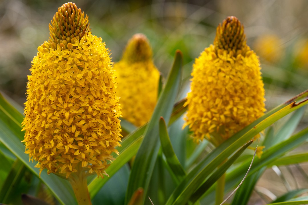
The tall rush/herb field association predominates in the high alpine mosaic of vegetation. It is dominated by the rushes Marsippospermum gracile and Bulbinella rossii (seasonally) but a wide range of grasses, forbs, lichens and bryophytes form a dense underturf. The bronzy green of most parts of the island above 300 metres (985 feet) is due to the dominant plants of this association. With the removal of grazing animals Pleurophyllum speciosum, Anisotome antipoda and dwarfed Stilbocarpa polaris are more common components of this association.
Other associations within this zone include that of the fellfield and bluffs dominated by lichens and mosses with vascular plants on sheltered ledges; wet cushion bog, cushion and mat species such as Scirpus aucklandicus, Gaimardia pallida, Coprosma pumila and Phyllachne clavigera and wet-flushed short rushland characterised by the rush Rostkovia magellanica and Juneus scheuchzerioides at lower altitudes.
Fauna
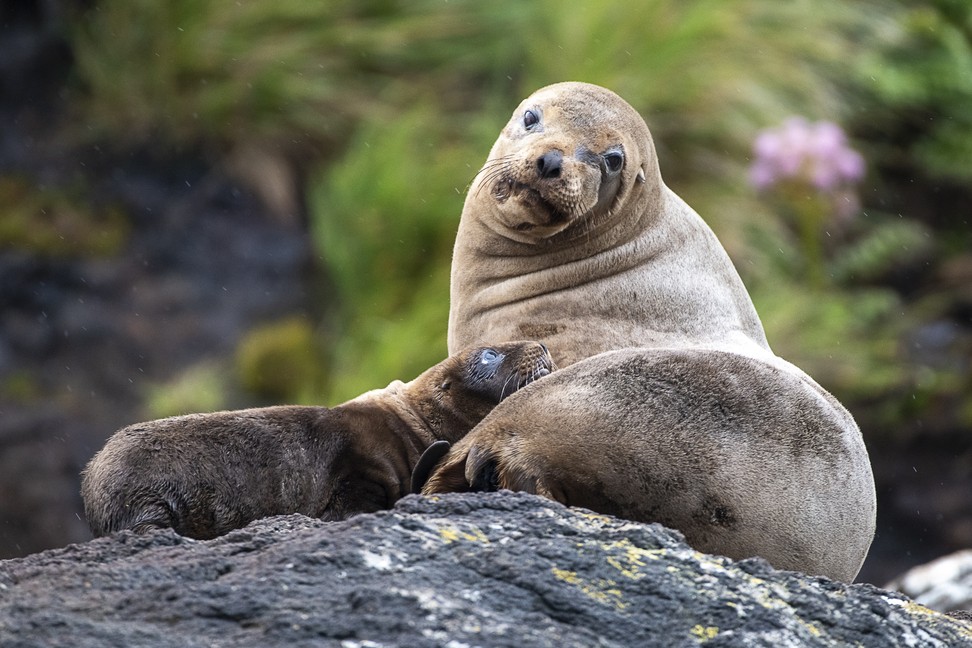
The number of Rockhopper Penguins has declined 94 per cent since the late 1950s, when the population was estimated at 1.6 million breeders. This crash is attributed to the lack of food caused by a southward shift of the nutrient-rich Convergence Zone. The island remains, however, an important breeding ground for Yellow-eyed Penguins.
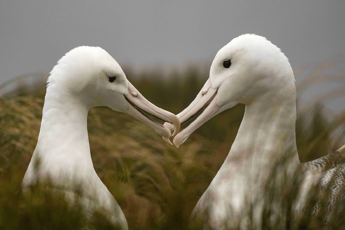
Campbell Island is of importance for breeding tubenoses, among them several globally threatened species of albatross. It holds almost the entire population of Southern Royal Albatross and is the sole nesting ground for Campbell Albatross. A relict, but apparently highly stable population of Antipodean Albatross also uses the island. Completing the albatross are Light-mantled Sooty Albatross, which are widespread on coasts and offshore islets.
The Sooty Shearwater, once found in great numbers, has been greatly reduced due to rat predation. The now globally threatened White-chinned Petrel can be seen among the offshore islands. The outer islands, which are free from rat predation, hold a wide array of birdlife.
This New Zealand region is particularly rich in cormorant taxa and the archipelago is home to the endemic Campbell Shag and Campbell Teal.
Campbell Island Teal
The Campbell Island Teal, Anas nesiotis, is a small, flightless, nocturnal species of dabbling duck of the genus Anas endemic to the Campbell Island group. It is sometimes considered conspecific with the Brown Teal. The plumage is similar to that of the Auckland Teal – dark sepia with the head and back tinged with green iridescence, and a chestnut breast on the male, with the female dark brown all over. Its natural habitat is tussock grassland dominated by Poa tussock grass, ferns and megaherbs. The species also uses the burrows and pathways of petrel species that nest on the islands. They are apparently territorial in the wild, and probably feed on amphipods and insects.
This teal is critically endangered, with a wild population of possibly less than 50 birds. Once found on Campbell Island, it was driven to extinction there by the introduction of Norway Rats which ate eggs and chicks. For a while it was presumed extinct. In 1975 it was rediscovered on Dent Island, a small (23 hectares or 57 acres) islet near Campbell that had remained rat-free. The population was so small that a single event could have driven it to complete extinction; to prevent this from happening 11 individuals were taken into captivity by the Department of Conservation for captive breeding at the Mount Bruce Wildlife Centre in 1984, and the rest followed in 1990. They were also put on the list of critically endangered species in 1979.
Captive breeding was initially very difficult to accomplish, as no studies on the behaviour of the species had been carried out in the wild and experiments with a range of techniques to encourage breeding were undertaken. Success came in 1994 when Daisy, the only wild origin female to ever lay eggs in captivity, finally accepted a mate. Subsequently, breeding has occurred every year – wild origin males contributed genes by pairing with captive raised females.
A small population of 25 captive-bred individuals was released on Codfish Island in 1999 and 2000 – already intensively managed and pest-free as an important habitat for the critically endangered Kakapo. In the final phase of the ecological restoration of Campbell Island (cattle, sheep and cats had already been removed), the world’s largest rat eradication campaign was undertaken by helicopter drops of more than 120 tonnes of poisoned bait over the entirety of the island’s 11,331 hectares (28,000 acres) area in 2001. This operation successfully removed what was estimated to be the world’s densest population of Norway Rats (200,000) from Campbell Island, which was officially declared rat free in 2003. Fifty Campbell Island Teal – a mix of captive-bred and wild-acclimatised animals (from Codfish) – were reintroduced to Campbell Island in mid 2004 after an absence of more than a century. Subsequent monitoring in 2005 showed that the majority of these birds are now thriving in their ancestral homeland.
Giant Petrel
The giant petrels are two large seabirds from the genus Macronectes. Long considered to be conspecific – they were not established as separate species until 1966 – the two species, the Southern Giant Petrel, M. giganteus and Northern Giant Petrel, M. halli, are the largest members of the petrel family, Procellariidae. They are considered, along with the two fulmars, to form a distinct sub-group within the petrels. Both species are restricted to the Southern Hemisphere, and though their ranges overlap greatly, notably in South Georgia, the Southern Giant Petrel nests further south, with colonies on Antarctica. Giant petrels are aggressive predators and scavengers, which has led to the other common name they have earned, ‘the Stinker’. The whalers used to call them gluttons.
Giant petrels earn their name. The Southern Giant Petrel is slightly larger at 3.8 to 8 kilograms (8.4 to 17.6 pounds), 180 to 210 centimetres (71 to 83 inches) across the wings and 86 to 100 centimetres (33 to 40 inhces) tall. The Northern Giant Petrel is 3 to 5 kilograms (6.6 to 11 pounds), 150 to 210 centimetres (60 to 83 inches) across the wings and 80 to 95 centimetres (30 to 38 inches) tall. Superficially, they resemble the albatross and are the only procellarids who can equal them in size. They can be told apart from the albatross by their bill; the two tube nostrils are joined together on the top of the bill, unlike albatross, whose nostrils are separated and on each side of the bill. The petrels are also much darker and more mottled brown (except for the Southern white morph) and have a more hunch-backed look.
The Southern and Northern Giant Petrels are harder to tell from each other, possessing similar long pale orange bills and uniform mottled grey plumage (except for 15 per cent of Southern Giant Petrels, which as morphs are almost completely white). The bill tip of M. halli is reddish-pink and that of M. giganteus is pale green, appearing slightly darker and lighter than the rest of the bill, respectively. Also, the underside of older M. halli is paler and more uniform than M. giganteus, the latter showing a contrast between paler head and neck and darker belly. Classic examples of Northern Giant Petrel are identifiable at some range. Unfortunately, young birds of both species are all dark and very hard to distinguish unless bill tip colour can be seen. Some relatively young Northern Giant Petrels can appear to be paler on the head, suggesting Southern Giant Petrel – thus this species is harder to confirm.
Giant petrels are highly opportunistic feeders, and uniquely for procellarids they will feed on land as well as at sea; in fact they find most of their food near the coast. On land they feed on carrion, particularly that of seals and penguins.
They are also the only petrel capable of walking well. They also display their dominance over carcasses with a ‘sealmaster posture’: the head and the wings are held outstretched, the head pointing at the opponent and the wingtips pointing slightly back; the tail is raised to a vertical position. They are also capable of killing other seabirds, even those as large as an albatross, which they kill either by battering them to death (most commonly chicks of other species during the breeding season) or drowning. At sea they feed on krill, squid and fish, often attending fishing fleets in hopes of picking up offal.
The Southern Giant Petrel is more likely to form loose colonies than the Northern. Both species lay a single egg in a rough nest built up off the ground and about 50 centimetres (20 inches) high. The egg is incubated for about 60 days, and once hatched the chick is brooded for three weeks. Chicks fledge after about four months but do not achieve sexual maturity for another 6 to 7 years after fledging.
Southern Rockhopper Penguin
The Southern Rockhopper Penguin, Eudyptes chrysocome, occurs in the Subantarctic waters of the Western Pacific and Indian Oceans, as well as around the southern coasts of South America.
Southern Rockhopper Penguins have a global population of roughly one million pairs. About two-thirds of the global population belongs to E. c. chrysocome which breeds on the Falkland Islands and on islands off Argentina and Southern Chile. These include most significantly Isla de los Estados, the Ildefonso Islands, the Diego Ramírez Islands and Isla Noir. E. c. filholi breeds on the Prince Edward Islands, the Crozet Islands, the Kerguelen Islands, Heard Island, Macquarie Island, Campbell Island, the Auckland Islands and the Antipodes Islands. Outside the breeding season, the birds can be found roaming the waters offshore of their colonies.
These penguins feed on krill, squid, octopus, fish, molluscs, plankton, cuttlefish and crustaceans. The breeding colonies are located from sea level to clifftop, and sometimes inland. The IUCN classifies the Southern Rockhopper Penguin as a vulnerable species; the population has declined by about one-third in the last 30 years. However, the Northern Rockhopper’s population is only a fraction of that of the Southern Rockhopper, and consequently the status of the latter is unchanged by the taxonomic split.
As noted above, Rockhopper Penguins are the most familiar to the general public of all the crested penguins. Their breeding colonies, namely those around South America, today attract many tourists who enjoy watching the birds’ antics. Historically, the same islands were popular stopover and replenishing sites for whalers and other seafarers since at least the early 18th Century. It is hardly surprising that almost all crested penguins depicted in movies, books and so on are ultimately based on Eudyptes chrysocome chrysocome.
Southern Royal Albatross
The Southern Royal Albatross, Diomedea epomophora, is the second-largest albatross, behind the Wandering Albatross. It has an average wingspan of almost 3 metres (10 feet), a length of 123 centimetres (49 inches) and a weight of 8.5 kilograms (18.8 pounds).
It was once considered conspecific with the Northern Royal Albatross Diomedea sanfordi as the Royal Albatross. The two species can be told apart at sea by the plumage of the wings on adults. The Southern Royal Albatross has large areas of white going down the wings, as opposed to the Northern Royal Albatross, which has entirely black wings. They are the whitest of all the albatross, with black wing tips and trailing edges when fully mature. They also lack the peach spot on the side of the head that Wandering Albatross have. Their legs are flesh-coloured, and their bill is pink with black cutting edges, creating a black line along the middle. The black line is a diagnostic difference from Wandering Albatross, but the bill is also paler and the white patterning on the wings is finer – ‘frosty’ rather than ‘blotchy’ and with the white spreading from the leading edge rather than out from the middle of the wing as birds mature – though some have small white spots in the middle of the wing.
Subantarctic Snipe
The New Zealand Snipe, Coenocorypha aucklandica, also known as the Subantarctic Snipe, is endemic to New Zealand. The nominate race is found on the Auckland Islands, excluding the main island. Other subspecies include C. a. huegeli which is found on the Snares Islands, and C. a. meinertzhagenae which is found on the Antipodes Islands. The introduction of the Pacific Rat Rattus exulans probably caused the extinction of the species from mainland New Zealand around 1,000 years ago, but the North Island and South Island subspecies managed to survive on offshore islands, the last refuge being Little Barrier Island, until the 1870s (Miskelly, 1988) and Big South Cape Island until 1964.
The Maori have legends about the hokioi or hakawai, a mythical bird which was only heard and never seen. Supposedly a giant bird of prey, this image was influenced by tales of the then extinct Haast’s Eagle and the loud noises attributed to the hokioi. However, Miskelly (1987; see also Galbreath & Miskelly, 1988) demonstrated that the tiny New Zealand Snipe was responsible for producing the loud rushing or screaming heard at night time during its mating flight, similar to the Common Snipe’s ‘winnowing’ and entirely out of proportion in loudness to the bird’s diminutive size. The snipe’s diet is made up principally of soil-dwelling invertebrates including larvae and pupae, reached by probing the ground to the full length of their bill.
The Subantarctic Snipe is noted for its elaborate courtship displays. It nests within cover, laying two pale brown, variably marked eggs. Incubation takes approximately 22 days, and once born, the chicks are fed by both parents for two to three weeks. The chick is able to fly within 30 days, and is completely independent within 65 days.
Flora
The vegetation of the Campbell Islands is predominantly tussock grassland, shrub land and herb field. Dracophyllum species, Coprosma species and Myrsine approach tree size – 5 metres or 16½ feet – in sheltered places. Limited tree growth results from high winds combined with cool temperatures. One introduced specimen of Picea (spruce) grows on the island and reaches about 6 metres or 19½ feet in height.
For ecological description, Meurk (1977) divides the vegetation into three super-oceanic altitudinal zones: the upper alpine, lower alpine and subalpine. Within these zones he also recognises several intra-zonal communities and some induced states. The most extensive associations are described below.
Sub-Alpine Zone
This zone is characterised by a dwarf forest of Dracophyllum scoparium and Dracophyllum longifolium, with Coprosma species and Myrsine, which in places attains a height of 5 metre (16½ feet).
Tall ferns, Polystichum vestitum and Histiopteris incisa, provide a lower middle stratum – about 1 metre (3.3 feet) high – in glades and bush margins. The ground layer comprises herbs such as Epilobium pedunculare, Stellaria decipiens and Uncinia species, as well as the mosses Ptychomnion densifolium and Acrocladium auriculatum. Epiphytic lichens Pseudocyphellaria species, Sphaerophorus species and Psoroma species), mosses (e.g. Macromitrium longirostre), liverworts and the ferns Grammitis magellanica and Hymenophyllum minimum are also present. The abundance of Myrsine and Coprosma seedlings along with the lack of Dracophyllum juveniles suggest that a true steady state has not yet been reached.
Other associations recognised within this zone are:
i) Poa tall tussock grassland. This is found on steep, windy slopes along the west coast and harbour shorelines. It can consist of nearly pure Poa litorosa, but Bulbinella rossii, Polystichum vestitum, Epilobium pedunculare, Stellaria decipiens, Acaena minor antarctica and Cardamine corymbosa are among the many sporadic associates.
ii) Tall tussock/megaherb field. Because of the highly palatable nature of the dominant plants i.e. Poa foliosa, Stilbocarpa polaris and Anisotome latifolia, 85 years of sheep grazing has greatly restricted the distribution of this association. With the removal of the sheep and the rats the megaherb fields are spreading and regaining dominance.
iii) Littoral/rock association. This tightly integrated association with a clear internal zonation is found either within the splash zone or on coastal cliff crests. Littoral lichens and the moss Muelleriella crassifolia, vascular plants such as Tillaea moschata, Scirpus cernuus and Colobanthus muscoides are found above brown and red seaweeds and blue-green algae. Inland of this band, Poa foliosa can be found.
iv) Salt marsh vegetation of Puccinellia chathamica, Cotula plumosa and Tillaea moschata is found on the upper reaches of tidal flats in the harbours.
Lower Alpine Zone
Chionochloa tall tussock grassland is now largely confined to the eastern extremities of the island, North East Harbour Valley, Beeman Hill, the island off Ramp Point at the eastern end of Penguin Bay, and some coastal cliffs. In its most developed phase Chionochloa antarctica is accompanied only by other tall species such as Polystichum vestitum (a fern), Pleurophyllum speciosum, and scattered shrubs. Smaller herbs are sparse and show the effects of lack of light. Dracophyllum scoparium and D.longifolium may dominate up to about 180 metres (590 feet) above sea level in sheltered areas. This association has greatly increased its range since the 1940s by invading tussock meadows made vulnerable through the burning and grazing of Chionochloa tall tussock vegetation.
Other associations include rock and ledge vegetation; Chionochloa/cushion bog ‘lanes’ (linear strips); as well as raised cushion bogs which develop around drainage patterns; Coprosma/Myrsine shrub flush; tall sedge swamp; tarn and riparian associations; pioneer mixed herb field on peat slips; and associations formed naturally in conjunction with bird and seal colonies.
Upper Alpine Zone
The tall rush/herb field association predominates in the high alpine mosaic of vegetation. It is dominated by the rushes Marsippospermum gracile and Bulbinella rossii (seasonally) but a wide range of grasses, forbs, lichens and bryophytes form a dense underturf. The bronzy green of most parts of the island above 300 metres (985 feet) is due to the dominant plants of this association. With the removal of grazing animals Pleurophyllum speciosum, Anisotome antipoda and dwarfed Stilbocarpa polaris are more common components of this association.
Other associations within this zone include that of the fellfield and bluffs dominated by lichens and mosses with vascular plants on sheltered ledges; wet cushion bog, cushion and mat species such as Scirpus aucklandicus, Gaimardia pallida, Coprosma pumila and Phyllachne clavigera and wet-flushed short rushland characterised by the rush Rostkovia magellanica and Juneus scheuchzerioides at lower altitudes.
Fauna
The number of Rockhopper Penguins has declined 94 per cent since the late 1950s, when the population was estimated at 1.6 million breeders. This crash is attributed to the lack of food caused by a southward shift of the nutrient-rich Convergence Zone. The island remains, however, an important breeding ground for Yellow-eyed Penguins.
Campbell Island is of importance for breeding tubenoses, among them several globally threatened species of albatross. It holds almost the entire population of Southern Royal Albatross and is the sole nesting ground for Campbell Albatross. A relict, but apparently highly stable population of Antipodean Albatross also uses the island. Completing the albatross are Light-mantled Sooty Albatross, which are widespread on coasts and offshore islets.
The Sooty Shearwater, once found in great numbers, has been greatly reduced due to rat predation. The now globally threatened White-chinned Petrel can be seen among the offshore islands. The outer islands, which are free from rat predation, hold a wide array of birdlife.
This New Zealand region is particularly rich in cormorant taxa and the archipelago is home to the endemic Campbell Shag and Campbell Teal.
Campbell Island Teal
The Campbell Island Teal, Anas nesiotis, is a small, flightless, nocturnal species of dabbling duck of the genus Anas endemic to the Campbell Island group. It is sometimes considered conspecific with the Brown Teal. The plumage is similar to that of the Auckland Teal – dark sepia with the head and back tinged with green iridescence, and a chestnut breast on the male, with the female dark brown all over. Its natural habitat is tussock grassland dominated by Poa tussock grass, ferns and megaherbs. The species also uses the burrows and pathways of petrel species that nest on the islands. They are apparently territorial in the wild, and probably feed on amphipods and insects.
This teal is critically endangered, with a wild population of possibly less than 50 birds. Once found on Campbell Island, it was driven to extinction there by the introduction of Norway Rats which ate eggs and chicks. For a while it was presumed extinct. In 1975 it was rediscovered on Dent Island, a small (23 hectares or 57 acres) islet near Campbell that had remained rat-free. The population was so small that a single event could have driven it to complete extinction; to prevent this from happening 11 individuals were taken into captivity by the Department of Conservation for captive breeding at the Mount Bruce Wildlife Centre in 1984, and the rest followed in 1990. They were also put on the list of critically endangered species in 1979.
Captive breeding was initially very difficult to accomplish, as no studies on the behaviour of the species had been carried out in the wild and experiments with a range of techniques to encourage breeding were undertaken. Success came in 1994 when Daisy, the only wild origin female to ever lay eggs in captivity, finally accepted a mate. Subsequently, breeding has occurred every year – wild origin males contributed genes by pairing with captive raised females.
A small population of 25 captive-bred individuals was released on Codfish Island in 1999 and 2000 – already intensively managed and pest-free as an important habitat for the critically endangered Kakapo. In the final phase of the ecological restoration of Campbell Island (cattle, sheep and cats had already been removed), the world’s largest rat eradication campaign was undertaken by helicopter drops of more than 120 tonnes of poisoned bait over the entirety of the island’s 11,331 hectares (28,000 acres) area in 2001. This operation successfully removed what was estimated to be the world’s densest population of Norway Rats (200,000) from Campbell Island, which was officially declared rat free in 2003. Fifty Campbell Island Teal – a mix of captive-bred and wild-acclimatised animals (from Codfish) – were reintroduced to Campbell Island in mid 2004 after an absence of more than a century. Subsequent monitoring in 2005 showed that the majority of these birds are now thriving in their ancestral homeland.
Giant Petrel
The giant petrels are two large seabirds from the genus Macronectes. Long considered to be conspecific – they were not established as separate species until 1966 – the two species, the Southern Giant Petrel, M. giganteus and Northern Giant Petrel, M. halli, are the largest members of the petrel family, Procellariidae. They are considered, along with the two fulmars, to form a distinct sub-group within the petrels. Both species are restricted to the Southern Hemisphere, and though their ranges overlap greatly, notably in South Georgia, the Southern Giant Petrel nests further south, with colonies on Antarctica. Giant petrels are aggressive predators and scavengers, which has led to the other common name they have earned, ‘the Stinker’. The whalers used to call them gluttons.
Giant petrels earn their name. The Southern Giant Petrel is slightly larger at 3.8 to 8 kilograms (8.4 to 17.6 pounds), 180 to 210 centimetres (71 to 83 inches) across the wings and 86 to 100 centimetres (33 to 40 inhces) tall. The Northern Giant Petrel is 3 to 5 kilograms (6.6 to 11 pounds), 150 to 210 centimetres (60 to 83 inches) across the wings and 80 to 95 centimetres (30 to 38 inches) tall. Superficially, they resemble the albatross and are the only procellarids who can equal them in size. They can be told apart from the albatross by their bill; the two tube nostrils are joined together on the top of the bill, unlike albatross, whose nostrils are separated and on each side of the bill. The petrels are also much darker and more mottled brown (except for the Southern white morph) and have a more hunch-backed look.
The Southern and Northern Giant Petrels are harder to tell from each other, possessing similar long pale orange bills and uniform mottled grey plumage (except for 15 per cent of Southern Giant Petrels, which as morphs are almost completely white). The bill tip of M. halli is reddish-pink and that of M. giganteus is pale green, appearing slightly darker and lighter than the rest of the bill, respectively. Also, the underside of older M. halli is paler and more uniform than M. giganteus, the latter showing a contrast between paler head and neck and darker belly. Classic examples of Northern Giant Petrel are identifiable at some range. Unfortunately, young birds of both species are all dark and very hard to distinguish unless bill tip colour can be seen. Some relatively young Northern Giant Petrels can appear to be paler on the head, suggesting Southern Giant Petrel – thus this species is harder to confirm.
Giant petrels are highly opportunistic feeders, and uniquely for procellarids they will feed on land as well as at sea; in fact they find most of their food near the coast. On land they feed on carrion, particularly that of seals and penguins.
They are also the only petrel capable of walking well. They also display their dominance over carcasses with a ‘sealmaster posture’: the head and the wings are held outstretched, the head pointing at the opponent and the wingtips pointing slightly back; the tail is raised to a vertical position. They are also capable of killing other seabirds, even those as large as an albatross, which they kill either by battering them to death (most commonly chicks of other species during the breeding season) or drowning. At sea they feed on krill, squid and fish, often attending fishing fleets in hopes of picking up offal.
The Southern Giant Petrel is more likely to form loose colonies than the Northern. Both species lay a single egg in a rough nest built up off the ground and about 50 centimetres (20 inches) high. The egg is incubated for about 60 days, and once hatched the chick is brooded for three weeks. Chicks fledge after about four months but do not achieve sexual maturity for another 6 to 7 years after fledging.
Southern Rockhopper Penguin
The Southern Rockhopper Penguin, Eudyptes chrysocome, occurs in the Subantarctic waters of the Western Pacific and Indian Oceans, as well as around the southern coasts of South America.
Southern Rockhopper Penguins have a global population of roughly one million pairs. About two-thirds of the global population belongs to E. c. chrysocome which breeds on the Falkland Islands and on islands off Argentina and Southern Chile. These include most significantly Isla de los Estados, the Ildefonso Islands, the Diego Ramírez Islands and Isla Noir. E. c. filholi breeds on the Prince Edward Islands, the Crozet Islands, the Kerguelen Islands, Heard Island, Macquarie Island, Campbell Island, the Auckland Islands and the Antipodes Islands. Outside the breeding season, the birds can be found roaming the waters offshore of their colonies.
These penguins feed on krill, squid, octopus, fish, molluscs, plankton, cuttlefish and crustaceans. The breeding colonies are located from sea level to clifftop, and sometimes inland. The IUCN classifies the Southern Rockhopper Penguin as a vulnerable species; the population has declined by about one-third in the last 30 years. However, the Northern Rockhopper’s population is only a fraction of that of the Southern Rockhopper, and consequently the status of the latter is unchanged by the taxonomic split.
As noted above, Rockhopper Penguins are the most familiar to the general public of all the crested penguins. Their breeding colonies, namely those around South America, today attract many tourists who enjoy watching the birds’ antics. Historically, the same islands were popular stopover and replenishing sites for whalers and other seafarers since at least the early 18th Century. It is hardly surprising that almost all crested penguins depicted in movies, books and so on are ultimately based on Eudyptes chrysocome chrysocome.
Southern Royal Albatross
The Southern Royal Albatross, Diomedea epomophora, is the second-largest albatross, behind the Wandering Albatross. It has an average wingspan of almost 3 metres (10 feet), a length of 123 centimetres (49 inches) and a weight of 8.5 kilograms (18.8 pounds).
It was once considered conspecific with the Northern Royal Albatross Diomedea sanfordi as the Royal Albatross. The two species can be told apart at sea by the plumage of the wings on adults. The Southern Royal Albatross has large areas of white going down the wings, as opposed to the Northern Royal Albatross, which has entirely black wings. They are the whitest of all the albatross, with black wing tips and trailing edges when fully mature. They also lack the peach spot on the side of the head that Wandering Albatross have. Their legs are flesh-coloured, and their bill is pink with black cutting edges, creating a black line along the middle. The black line is a diagnostic difference from Wandering Albatross, but the bill is also paler and the white patterning on the wings is finer – ‘frosty’ rather than ‘blotchy’ and with the white spreading from the leading edge rather than out from the middle of the wing as birds mature – though some have small white spots in the middle of the wing.
Subantarctic Snipe
The New Zealand Snipe, Coenocorypha aucklandica, also known as the Subantarctic Snipe, is endemic to New Zealand. The nominate race is found on the Auckland Islands, excluding the main island. Other subspecies include C. a. huegeli which is found on the Snares Islands, and C. a. meinertzhagenae which is found on the Antipodes Islands. The introduction of the Pacific Rat Rattus exulans probably caused the extinction of the species from mainland New Zealand around 1,000 years ago, but the North Island and South Island subspecies managed to survive on offshore islands, the last refuge being Little Barrier Island, until the 1870s (Miskelly, 1988) and Big South Cape Island until 1964.
The Maori have legends about the hokioi or hakawai, a mythical bird which was only heard and never seen. Supposedly a giant bird of prey, this image was influenced by tales of the then extinct Haast’s Eagle and the loud noises attributed to the hokioi. However, Miskelly (1987; see also Galbreath & Miskelly, 1988) demonstrated that the tiny New Zealand Snipe was responsible for producing the loud rushing or screaming heard at night time during its mating flight, similar to the Common Snipe’s ‘winnowing’ and entirely out of proportion in loudness to the bird’s diminutive size. The snipe’s diet is made up principally of soil-dwelling invertebrates including larvae and pupae, reached by probing the ground to the full length of their bill.
The Subantarctic Snipe is noted for its elaborate courtship displays. It nests within cover, laying two pale brown, variably marked eggs. Incubation takes approximately 22 days, and once born, the chicks are fed by both parents for two to three weeks. The chick is able to fly within 30 days, and is completely independent within 65 days.
READ LESS
Further Reading
Further Reading:
- Chilton, C (Ed) The Sub Antarctic Islands of New Zealand Vol 1& 2 Philisophical Insitute of Canterbury, Wellington, 1909.
- Fraser, C Beyond the Roaring Forties, Woolmore Printing Ltd, Auckland 1986.
- Higham, T (Ed) Sub Antarctic Islands - A Guide Book, Craig Printing Co Ltd, Invercargill 1991.
- Kerr, I S Campbell Island A History, A H and A W Reed, Wellington, 1976.
- Kerr, I S and Judd, N Marlborough Whalers at Campbell Island, 1909 - 1916. Department of Lands and Survey, Wellington 1978.
- Sorenson, J H Wildlife in the Sub Antarctic, Whitcombe and Tombs Ltd 1951.
- Thomas, M C Forgotten Islands of the South Pacific - the Story of New Zealand's Sub Antarctic Islands by Rosaline Redwood. A H and A W Reed, Wellington.
- Shirihai Hadoram A Complete Guide to Antarctic Wildlife. Alula Press Oy, Finland 2002.
- Dept of Conservation: Subantarctic Islands Heritage. (Nomination of the New Zealand Subantarctic Islands by the Government of New Zealand for inclusion in the World Heritage List. Wellington. 1997.
BLOG
Campbell Island
01 Apr 2025
The recent "In the Wake of Scott & Shackleton: Ross Sea Antarctica" expedition aboard Heritage Adventurer has concluded. The Species List for thi…READ MORE
11 Mar 2025
Heritage Expeditions and the Russ family were praised for setting the New Zealand standard in responsible expedition tourism during an exclusive ev…READ MORE
01 Mar 2025
The recent "In the Wake of Scott & Shackleton: Ross Sea Antarctica" expedition aboard Heritage Adventurer has concluded. The Species List for thi…READ MORE


ebell_campbell_albatross_off_campbell_island_during_chumming.jpg)
.jpg)
_%C2%A9_j.potter.jpg)
ebell_campbell_albatross_slow_motion_flying_(custom).jpg)
kovsyanikova_galapagos_of_the_southern_ocean_(13).jpg)